
Seasonal Outlook: Winter 2022/2023
(Released: October 26, 2022)
DISCLAIMER:
For
those of you that have not viewed my outlooks, I strongly suggest you
check out my
"Soap Box Speech on Seasonal Weather Forecasting". The
bottom line is, no one should be making any serious decisions, such
as buying/not buying a sled or gear based on this or any outlook.
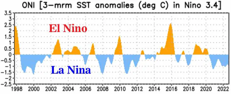
THE TOOLS: As usual, the first and most important thing I look at when producing this outlook is to take a look at the El Nino/Southern Oscillation (ENSO) levels and predictions. Since mid-summer of 2020, the surface water temps in the central and eastern Pacific have been cooler than average and in a La Nina state (Figure 1). Generally speaking, La Nina’s increase the chance for an at least average winter in the Midwest, if no colder and snowier. The opposite is true for El Nino, the warn water event. The strength of the current La Nina during these past 2 years has varied, but has never reached an exceptionally strong state. The duration of this La Nina is also not exceptional, although it should be noted that such events do not typically last much longer than 2 years.
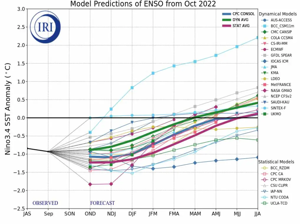
The differing forecast models have their typical differing ideas, but the general idea sees the current La Nina to continue through the winter of 22-23 and then weaken to a neutral state by the spring of 2023. sea surface temps to cool a bit further for the next few months and then begin to warm during the second half of the winter (Figure 2). This is a pretty good signal for snow lovers in most of the Midwest, as long as the warming does not accelerate to the point where the La Nina ends mid-winter.
There are also several other tools that I have been developing and using over the years to produce my seasonal outlooks and each year they do seem to get more refined and more useful. I am still not even close to dismissing my Soap Box Speech, but the degree of errors in my seasonal outlooks has been on a down trend for the past 6-7 years and last years prediction of a colder and snowier winter for the far northern Midwest verified, as did the idea for IA, southern WI and northern IL to see a less snowy winter than averagew. I do like to keep these other tools close to my chest, as they are proprietary. So please do not inquire about them!
With that said, let’s get to the outlook!
|
I have done away with the “Regional” breakdown to the forecast, as I found that the weather ideas in the outlook did not always align themselves too well with the outlines of the regions. I hope you find this new format easier to read and understand, because I think it will be sticking around for a while! - John
PLEASE DO NOT REPOST FORECAST GRAPHIC !