|
Seasonal
Outlook: Winter 2021/2022 (Released: October 15, 2021) Disclaimer. With
the usual disclaimer over, it is time to get down to the nuts and bolts. As
usual, the first and most important thing I look at when producing this outlook
is to take a look at the El Nino/Southern Oscillation (ENSO) levels and
predictions. Since spring of 2020, the surface water temps in the central and
eastern Pacific have been cooler than average an in a La Nina state (figure
1). The strength of the La Nina at this time is not as strong as it was
last year at this time (figure
2). The
differing forecast models have their typical differing ideas, but the general
idea sees the sea surface temps to cool a bit further for the next few months
and then begin to warm during the second half of the winter (figure
3). This is a pretty good signal for snow lovers in most of the Midwest,
as long as the cooling does not get as aggressive as last winter. I
also have a handful of other tools that I have been developing over the years to
produce my seasonal outlooks and each year they do seem to get more refined and
more useful. I am still not even close to dismissing my Soap Box Speech, but the
degree of errors in my seasonal outlooks has been on a down trend for the past
5-6 years, with last year having an up tick, due to failures in the northern
Plains and northern Midwest. I do like to keep these other tools close to my
chest, as they are proprietary. So please do not inquire about them! With
that said, let’s get to the outlook!
Before
I get into the regional breakdown, I would like to make a point. One
note that I want to make about “average” is that it does not mean average
for all of the season, but rather average for the season as a whole. It may mean
the first half is warmer with less snow than average and the second half is
colder and snowier than average. Or it could be the opposite. It could also be a
period of very cold and snowy, with the rest of the season less snowy and warmer
than average…or some combination there-as. Here
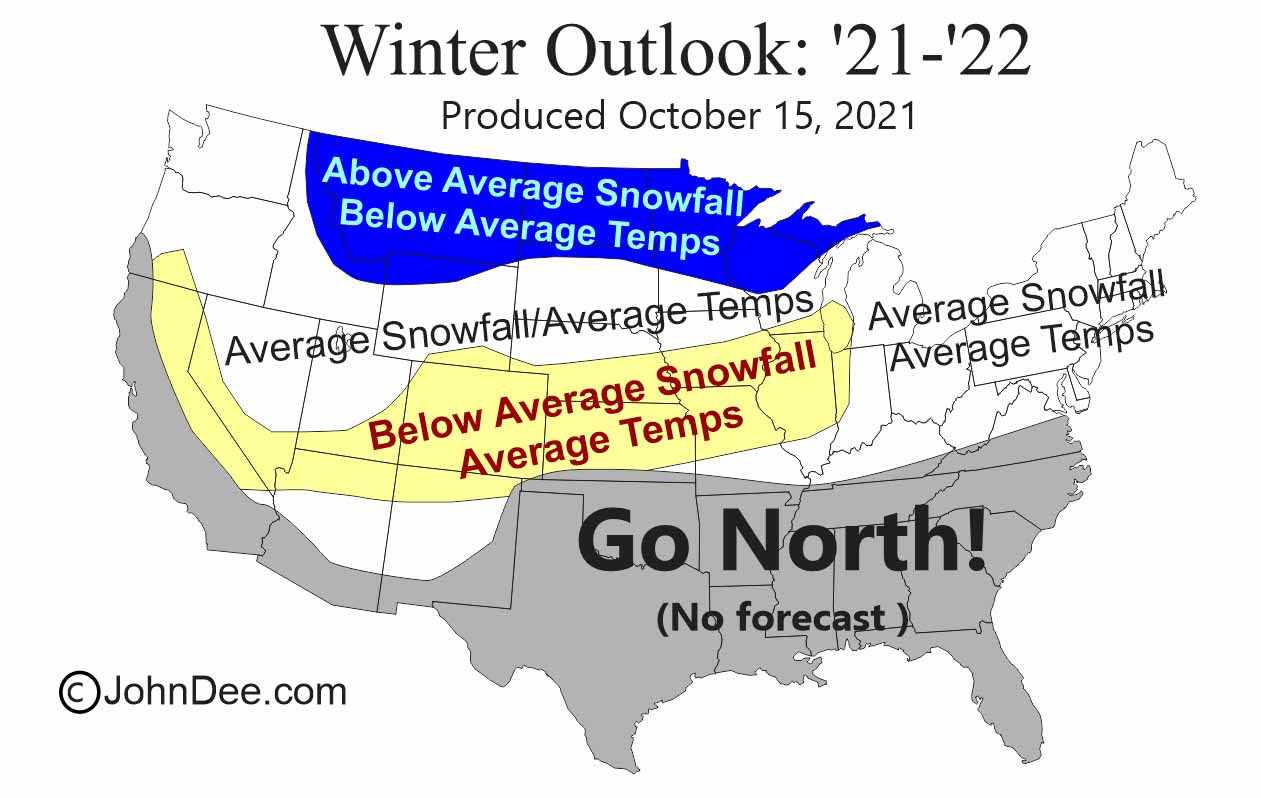
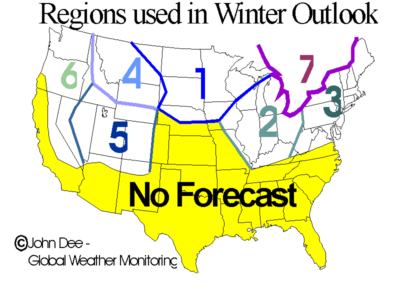
is the breakdown by region: REGION
1 – The Northwest Midwest: The news for the northern ½
of this region is good. It is earmarked for the best chances for below average
temps and above average snowfall this season. Keep in mind that there are always
exceptions and every spot in the blue shaded area might now see a colder and
snowier winter. I also believe that the best chances for above average
snowfall are in the lake effect regions of the northern upper peninsula. Lake
surface temps are currently very much above average and although it is only the
top 15-25 feet that is that warm, we are getting very close to the beginning of
the lake effect snow season and the warmer temps could lead to heavier than
usual early season snow. The news for the southern ½ is not as good. I see
average temps as the best likelihood, but below average snowfall. REGION
2 – The Southeast Midwest: The news for this
region is not bad in the east, with average temps and average snowfall, but the
western ½ looks to see below average snowfall, coupled with average temps.
These areas have actually seen better than average snowfall in the past few
years, so I guess it is time to balance things out a bit. The only other point I
always like to make for this region is that a lot of people over estimate the
averages for their locale. Areas like northern IL, southern WI and southern MI
see an 45-55” of snow fall on average, not 60-70” as some think! Also, there
are typically at least a few warm-ups that occur and damage if not destroy the
snow on the ground. REGION
3 – The Northeast US: The forecast for this
region is OK. It looks like snowfall for the season as a whole will run near
average. Temps also look to run close to average as a whole. I wish I could be
more detailed for this region, but there are just not that many tool available
to produce any kind of reliable seasonal prediction. REGION
4 – The Northern Rockies: Most of this region
looks to see above average snowfall and below average temps occur for the winter
as a whole. Snows have already begun to fall and are sticking around in the
highest of terrain and it will not be long before the ground is white for the
season in many of the traditional snow-play areas. REGION
5 – The Central Rockies: This majority of the
region looks to see temps run near average for the winter as a whole, with
Colorado, southern UT and northern AZ seeing less than average snowfall. REGION
6 – The Pacific NW and Sierra Range: This region
is split in half as far as my ideas for this snow season goes. For the north,
places like WA and OR, I see it as a pretty good winter for both snow and temps.
Further south, I fear that the La Nina will cause the Pacific storms to by-pass
CA for the most part, leaving them with a drier than average snow season. Not
that it will be bone dry, but I am just not very optimistic about this region. I
also think there could be the chance for above average temps during much of the
snow season. I am not confident enough to put it on the map, but do have a fear
it could happen. REGION
7 – Eastern Canada: The story northern and
western Ontario, northern Quebec and the Canadian Maritime Provinces of
Newfoundland looks good. I feel plenty of cold air will be in place and the
storm track will also be active enough to produce above average snowfall. The
story for the rest of eastern Canada is not bad, with close to average temps and
snowfall. PLEASE DO NOT REPOST FORECAST GRAPHIC !
|
|||||||
|
|