|
Seasonal
Outlook: Winter 2020/2021 (Released: October
15, 2020)
With the usual disclaimer over, it is time to get down to
the nuts and bolts. As
usual, the first and most important thing I look at when producing this outlook
is to take a look at the El Nino/Southern Oscillation (ENSO) levels and
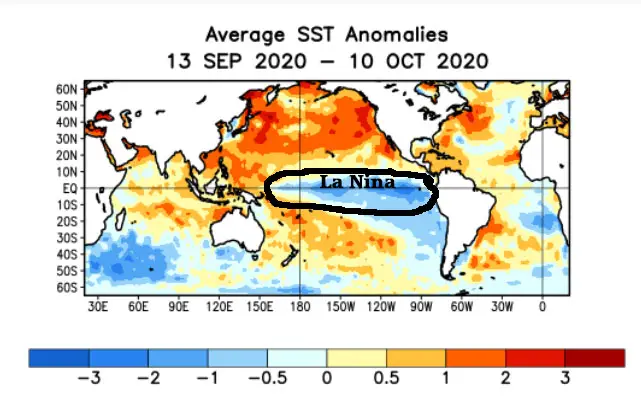
predictions. Since spring, the surface water temps in the central and eastern
Pacific in the vicinity have been cooling and are now in a La Nina state (figure
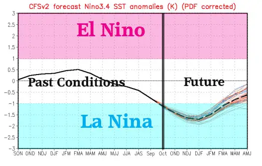
1). The
forecast sees the sea surface temps to cool further into the first half of the
winter and then begin to warm during the second half (figure
2). This is a pretty good
signal for snow lovers in the Midwest. I
also have a handful of other tools that I have been developing over the years to
produce my seasonal outlooks and each year they do seem to get more refined and
more useful. I am still not even close to dismissing my Soap Box Speech, but the
degree of errors in my seasonal outlooks has been on a down trend for the past
4-5 years. Knock on wood! I do like to keep these other tools close to my chest,
as they are proprietary. So please do not inquire about them! With that said, lets get to the outlook! As
usual, I am going to let the graphic do most of the talking and use the text to
fill in the details or speak about things that cannot be represented on the map.
he bottom line is that the other tools I use to produce my outlook are all in
the same boat. Thus
I
think for most of the north central US, including the traditional winter play
areas of the Northwoods of the Midwest, it will be a winter that provides
below average temps and above average snowfall. Before
I get into the regional breakdown, I would like to make a point. One
note that I want to make about average is that it does not mean average
for all of the season, but rather average for the season as a whole. It may mean
the first half is warmer with less snow than average and the second half is
colder and snowier than average. Or it could be the opposite. It could also be a
period of very cold and snowy, with the rest of the season less snowy and warmer
than average
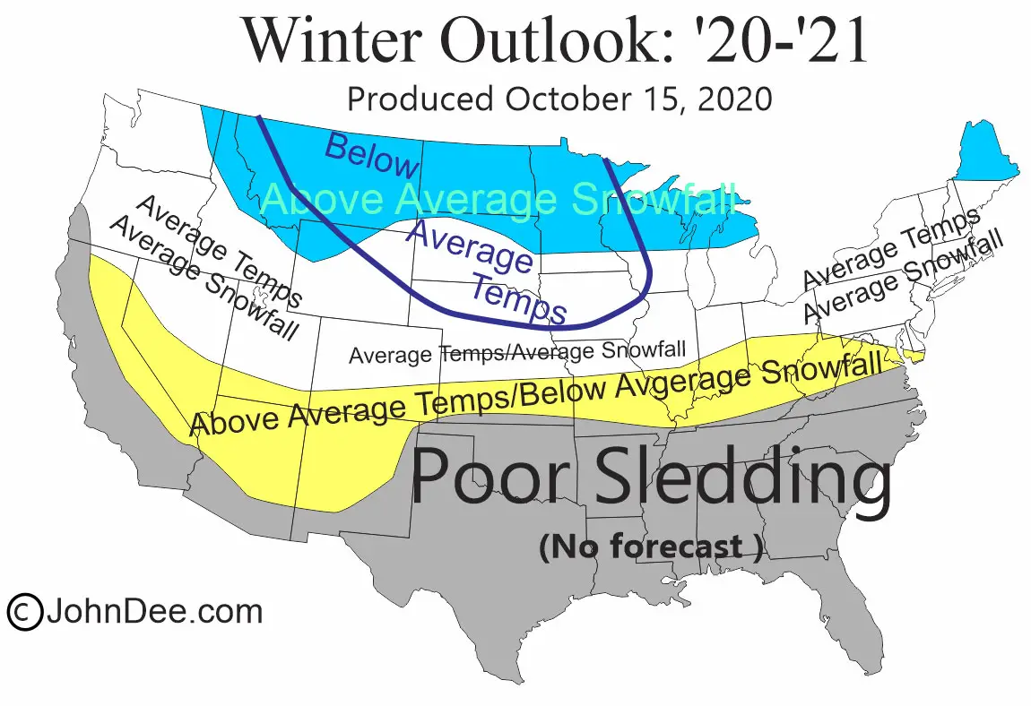
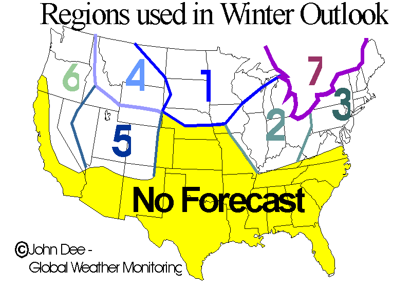
or some combination there-as. Here is the breakdown by region: REGION 1
The Northwest Midwest: The
news for this region is good. It is earmarked for the best chances for below
average temps and above average snowfall this season. Keep in mind that there
are always exceptions and every spot in the blue shaded area might now see a
colder and snowier winter. Another
caveat to the idea
for this region is that the true colder and snowier than average conditions
might not arrive until the second half of the winter. None the less, the outlook is quite promising! REGION
2 The Southeast Midwest: The news for this region is not bad, but not
as promising as that of the neighbors to the NW. Most of this region looks to
see an average winter as a whole. There may also be a slight bias for the second
half of the winter to be snowier than the first half. My only other note to make
is that a lot of people over estimate the averages for their locale. Areas like
northern IL, southern WI and southern MI see an 45-55 of snow fall on
average, not 60-70 as some think! Also, there are typically at least a few
warm-ups that occur and damage if not destroy the snow on the ground. REGION
3 The Northeast US: The forecast for this region is OK. It looks like
snowfall for the season as a whole will run near average. The exception looks to
be the northern ½ of Maine, where below average temps and above average
snowfall is a good possibility. REGION
4 The Northern Rockies: Most of this region looks to see above average
snowfall and below average temps occur for the winter as a whole. REGION
5 The Central Rockies: This majority of the region looks to see temps
and snowfall run near average for the winter as a whole. The exceptions would be
in the far south, where areas like southern Colorado could see below average
snows. REGION
6 The Pacific NW and Sierra Range: Most of this region will likely see
average snowfall and temps. Like the other mountainous regions, most of the
snow-play is done in the higher terrain, so the average temps should not lead to
much of an issue and there will likely be plenty of snow fall to allow
snow-play. REGION 7 Eastern Canada: The story for eastern Ontario, most of Quebec and the Maritime Provinces is pretty similar to the north central US. Thus, I believe snowfall will be above average for most areas and temps will run below a
PLEASE DO NOT REPOST FORECAST GRAPHIC !
|
|||||
|
|
