|
Seasonal
Outlook: Winter 2017/2018 Released:
October 12, 2017 By
now, I am sure that close to all of you are familiar with my feelings on
seasonal weather forecasting, but for those of you that have not done so
already, you might want to check out my "Soap Box
Speech on Seasonal Weather Forecasting". The bottom line is, no one
should be making any serious decisions, such as buying/not buying a sled or gear
based on this or any outlook. With the usual disclaimer over, it is time to get down to
the guessing…er…business. After a dismal, El Nino induced, winter back in
2015-16, there were hopes that the developing La Nina would bring a cold and
snowy winter. For a period in December and early January, those hopes seemed to
be getting fulfilled. However, the wheels came off in mid-January and the rest
of the winter was a major disappointment for the Midwest. We actually find ourselves in a somewhat similar
situation as a year ago, as the seas surface temperatures in the Equatorial
Pacific are nearing La Nina status. (figure 1). However, that is just a snapshot
version of how things are now, compared to how they were a year ago. I could
compose a whole presentation explaining how things are different this go around,
but time forbids and most of you just want to know what the winter is going to
be like! So with that said, I do believe that there is a good
chance a La Nina will be in place by the time the snow starts to fly in earnest
in the Midwest and will last through the winter. The La Nina is just one
factor I am taking into account to produce my outlook and like to keep the other
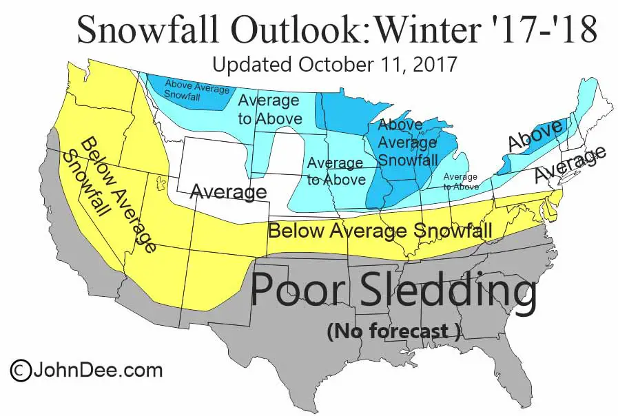
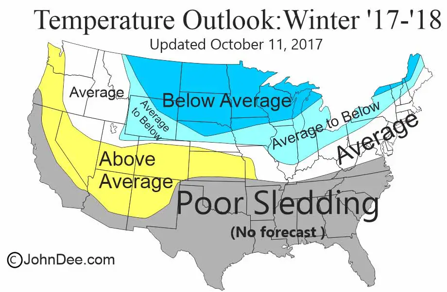
“tools” somewhat close to my chest for business reasons. As usual, I am going to let the graphic do most of the
talking, but I believe that there are increased chances that the winter of
2017-18 will present average to above average snowfall and average to below
average temps across much of the Midwest, with the exceptions being the far
southern Midwest. (figures 2 & 3). PLEASE keep in mind that there
are HUGE differences between putting together a seasonal outlook and a forecast
for the next few days. A seasonal outlook is just one notch able a pure guess! I also believe that the current mild conditions across
the eastern 2/3rds of the US will continue through the rest of October and into
at least early November. So those looking for early snows and cold will likely
be disappointed, but the deeper we go into November, the greater the likelihood
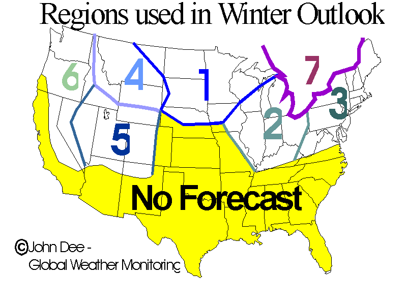
that the pattern will make its flip and start to send in the cold and snow. Here is the breakdown by region: REGION
1 – The Northwest Midwest: The news is good. This may not be an exceptional
year for snows in some spots, but for others, like northern MN, much of WI and
the UP, snowfall has a good chance to be above average and when combined with
frequent intrusions of arctic air leading to below average temps in general,
will lead to prolonged periods where snow play will be able to be had. These
intrusions of arctic air will also set the stage for an increased chance for
more lake effect snow (LES) than is seen in a typical season across the LES
belts of the UP. Although one should not necessarily set their expectations on a
record setting season for LES snow in the UP. REGION
2 – The Southeast Midwest: The news for this region is pretty good in
the north and not good in the south. I think that for most of lower MI and the
northern sections of IL/IN/OH will join in on the colder and snowier than
average winter the northwest Midwest sees. Perhaps not to the degree that the NW
Midwest sees, but still on that side of the fence. La Nina’s tend to produce
warmer than average temps in the southern US and I believe that anomaly may
extend far enough north to impact the southern sections of IL, IN and OH. REGION
3 – The Northeast US: In general, I see this region running near average
for both temps and snowfall, with the far west seeing an increased chance for
above average snowfall and below average temps. La Nina does not link itself
very well with weather anomalies in the NE US, so confidence in this forecast is
not as high as it is for the north central US, but I still believe that the
weather anomalies in the north central US will impact this region more so than
not. I also fear that this region may take longer to see true winter weather
arrive, but still should be happening by the second half of December. REGION
4 – The Northern Rockies: For most of Montana, I believe it will be a
colder and snowier than average winter, especially the front half, with perhaps
the back half seeing those trends moderate. The rest of the region looks to see
somewhat changeable weather this winter- resulting in close to average snow and
temps for the winter as a whole. The warmer spells will likely impact only the
lower elevations where snow-play is done, with the more traditional, higher,
elevations seeing little in the way of thaws occur during the heart of the
season. REGION
5 – The Central Rockies: I see the northern ½ of this region to see
close to average snowfall and temps occur, but as you travel south, the number
of storms rolling through is likely to be smaller and thus an increased chance
for below average snowfall will occur. In addition to the increased chance for
below average snowfall will come more sunshine and slightly warmer than average
conditions. So lots of sunshine, but perhaps not as much snow as would be
desired. REGION
6 – The Pacific NW and Sierra Range: Most of this region will likely see
below average precipitation result in below average snowfall for the higher
terrain. The expected pattern does include the CA mountains, with storms to be
less frequent and temps to run average to even a bit above. REGION
7 – Eastern Canada: The story for eastern Ontario, most of Quebec and
the Maritime Provinces is pretty similar to the western sections of the
Northeast US. Meaning that I believe
the winter will be a bit cooler than average, with the snowfall to running
average to above average.
|
||||||||
|
|